Double dip: Antarctic sea ice sinks to new low for winter
10 September 2024
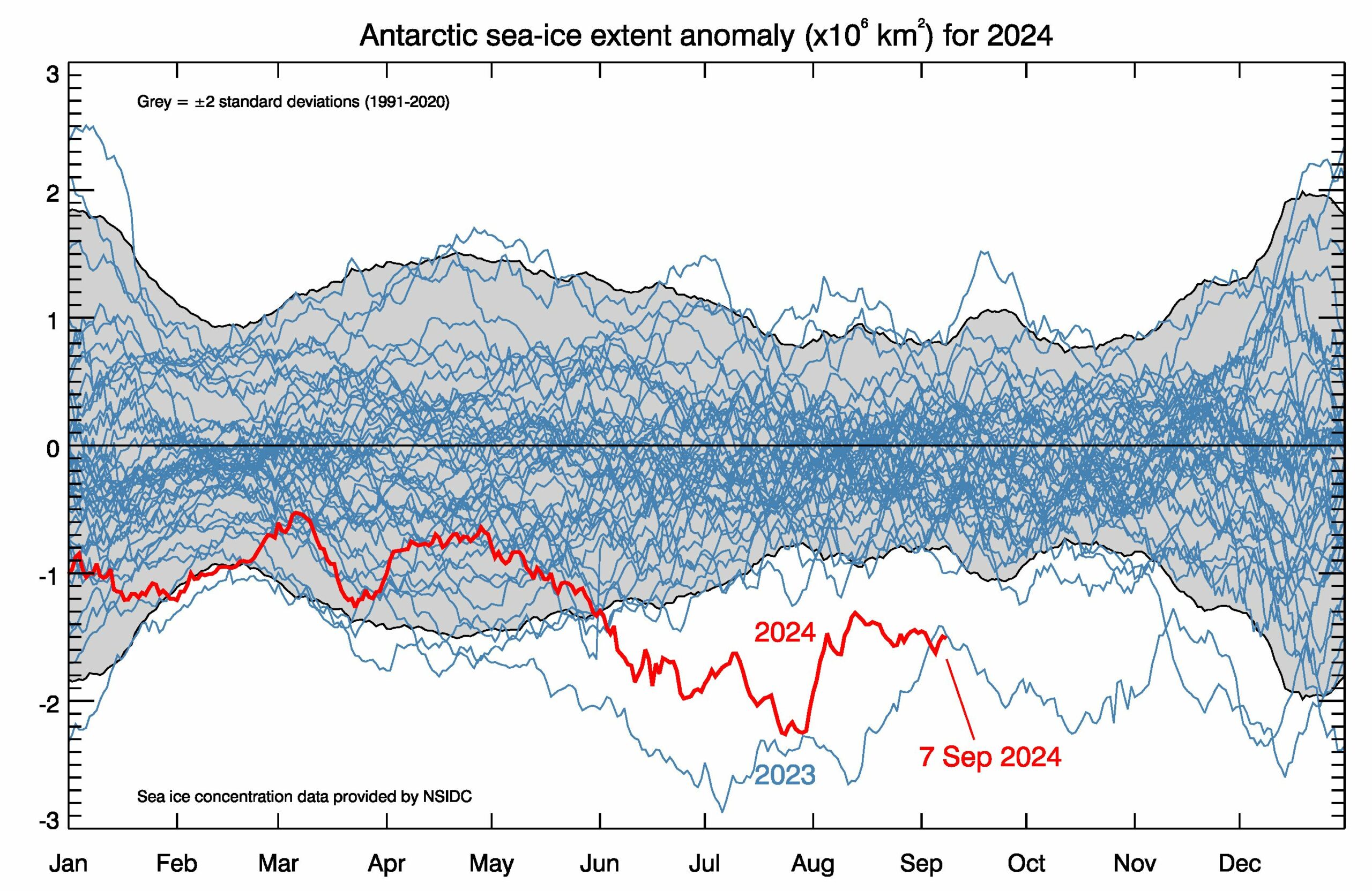
For the second winter in a row, the extent of Antarctic sea ice has been exceptionally below average — and it has just set a new record low for this time of year.
Throughout 2024 scientists in Hobart have been anxiously monitoring sea-ice extent, after last year’s sea-ice coverage was at the lowest levels since satellite records began.
Sea-ice researcher Dr Will Hobbs, of the Australian Antarctic Program Partnership (AAPP) at the University of Tasmania, said the record seasonal low is further indication that the sea-ice system around Antarctica is shifting to a new state.
“In 2023, the winter extreme was outside everybody’s expectations – not just due to its sheer magnitude, but because it’s the wrong time of year. In winter the ocean should be freezing.”
“While the summer sea ice of 2024 was largely within the ‘normal’ variability, this winter we’ve again seen chaotic fluctuations similar to last year, now producing the lowest winter extreme on record,” he said.
“At short time-scales – months to years – the atmosphere is the main driver of regional variability in Antarctic sea ice. What’s different now is that warmer Southern Ocean temperatures are really having an impact on the sea ice.”
“The big question is whether that ocean warming is just a blip or is it related to climate change. Getting two such extreme events back-to-back is like throwing two double-sixes in a row – how many double-sixes do you need before you start thinking the dice are loaded?”
“We know that the past two years have been the warmest on record for the planet, with global temperatures more than 1.5oC above pre-industrial for extended periods. This global warmth is now reflected in the oceans around the Antarctic, and is likely a major factor in continuing record low sea ice,” said Dr Hobbs.
Every day Dr Phil Reid of the Bureau of Meteorology (an AAPP partner agency) plots satellite data from the US National Snow and Ice Data Centre at the University of Colorado.
“While it’s still too early to say whether winter sea ice has reached its maximum this year, it’s startling that the extent has dropped so low again – almost like the sea ice is being dissuaded from growing!”, Dr Reid said.
On 7 September, sea-ice extent reached only 17.0 million square kilometres, compared to the previous low winter-time extent on the same day in 2023 of 17.1 million square kilometres. The long-term normal for this date is 18.4 million square kilometres.
“”We are really only just beginning to understand the effects on our weather and climate from regionally low sea-ice coverage, combined with much warmer-than-normal ocean temperatures.”
“For example, recent studies suggest that reduced sea-ice extent may lead to an increase in occurrence and duration of summer-time wet extremes over Australia, and, conversely, longer periods of dry days during winter.”
“Ocean and atmosphere interactions, induced by Antarctic sea-ice loss, are thought to drive these changes.”
“There are also key characteristics of sea ice that we can’t measure particularly well – like its thickness. It is possible that some of the sea ice being observed this year is quite thin, thinner than average, and vulnerable to atmospheric perturbations.”
“It is a gap in the knowledge of our sea-ice environment that we need to fill, because our polar environments are changing rapidly,” said Dr Reid.