Tasting the many flavours of Antarctic ocean
Dr Sophie Bestley (IMAS/AAPP)
The CTD instrument (standing for Conductivity-Temperature-Depth) is the workhorse of any marine research voyage. In bad weather, it’s the last operation to be called off, and the first to go back into the water. On a cruise like MISO, underway on CSIRO research vessel (RV) Investigator, CTD stations provide the skeleton around which all the other planned operations are built.
On MISO, the major aim for the CTD and carbon teams is to repeat observations at historical sites, to discover how and why the region is changing and the consequences of Southern Ocean change for climate, biogeochemical cycles, biological productivity, and the future of the Antarctic Ice Sheet.
What does a day in the life of the team look like at sea? In two rotating 12-hour shifts we have three CTD and two carbon personnel working to “dip” and “sample” the CTD. Many wonder why we’re calling winch depths across the shipboard comms?
On the dip, we watch the live traces on the CTD downcast, as real-time data on ocean properties relay to screens in the ops room. How warm, salty, and oxygenated is the water? In the upper zone at what depth does light decay away, and how does the subsurface spike in the fluorescence (and backscatter) trace show where tiny ocean plants called phytoplankton are balancing their need for light from above, and nutrients from below?
The full voyage plan has 100 CTD casts. Depending on the seafloor depth, a cast might be a lengthy 4.5 hours to 4500m, or a sharp sudden dash to the shallow Antarctic shelf at only 800m and all choices need to be rapid.
We watch for signatures in the data traces, diagnosing key water masses like a layer cake. In specific areas around Antarctica, at the seafloor we watch for a jump in oxygen and drop in temperature and salinity, indicating fresh Antarctic Bottom Water (AABW) recently formed in the Adelie Depression near the Mertz glacier. A saltier signature here would indicate that the bottom water origin is farther east in the Ross Sea, and we see that on the 150E line.
In a typical Antarctic cast, above the AABW we see a thick layer (and I mean a couple of thousand metres) of Lower Circumpolar Deep Water (LCDW), the core of which has the saltiest signature, ie. salinity maximum. Its origin was as North Atlantic Deep Water, and now it’s slowly circulating through the Southern Ocean – hence the name change. Overlying LCDW is the warmer version, Upper Circumpolar Deep Water (UCDW). This is the oldest water mass, in contact with the atmosphere at the surface the longest time ago, maybe several hundred years. We see this in the subsurface oxygen minimum / temperature maximum.
Antarctic Surface Water (AASW) occupies the top of the water column and may have two distinct layers. During summer, warming can make a shallow (20-80m) seasonal mixed layer, which overlies a cold layer of Winter Water. This has a characteristic temperature minimum less than 0°C and holds the memory of last winter’s deep mixing of the surface waters.
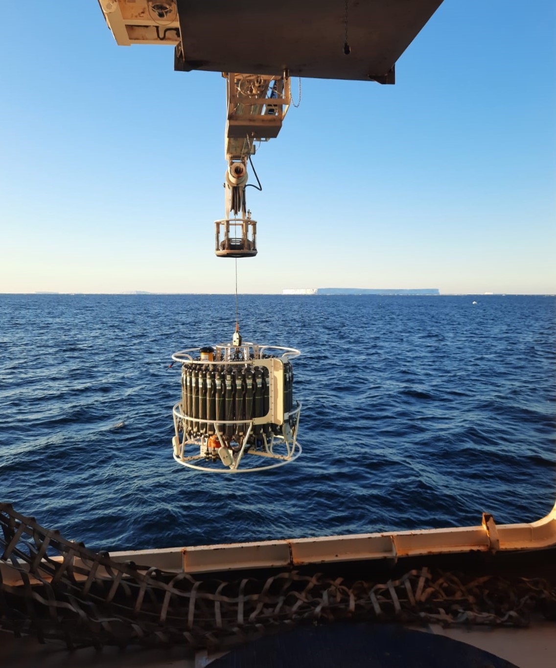
On RV Investigator, the CTD is an impressive size, carrying a rosette with 36 niskin bottles. These are cocked open for descent, and on the upcast, we fire them closed at depths chosen to catch all the key features described above. With the first bottle we try to capture water samples within 6-10m of the seafloor, particularly if we are chasing the valuable AABW, and we always duplicate fire that one just in case. How this densest water mass is changing, freshening, and contracting, due to changes in the sea, ice and atmospheric properties and processes is one of the long-term questions being addressed on this voyage.
Once the CTD is safely back on deck, our teams do a synchronised dance around the rosette, sampling for oxygen and salts to help calibrate the data streams, and also bottle samples for carbon and nutrient analysis (including nitrate, phosphate, silicate, and ammonia) for which there are no automated sensors. Gases are sampled for first, as there is a strict hierarchy once a bottle valve is cracked! Depending on the site, once we’re done the CTD room can fill with several other teams, sampling paleo-radiogenics (for tracing the history of water using concentrations of natural isoptopes), biology, genomics and more, helping to put all the pieces of the puzzle together.
Although providing extremely precise information, a ship can be in only one place at a snapshot in time. To help us get more detailed timeseries, our team is also deploying sophisticated Deep and Biogeochemistry Argo floats, relaying data via satellite long after we’ve finished our hectic roles at sea.
Key MISO questions include:
- How and why is the Southern Ocean inventory of heat and carbon south of Australia evolving in time and what are the impacts on sea level rise and ocean acidification?
- How is the Southern Ocean changing near Antarctica and what are the implications for the stability of the Antarctic Ice Sheet and the formation of Antarctic Bottom Water?
CTD rosette is lowered (photo: Brendan Coulson) 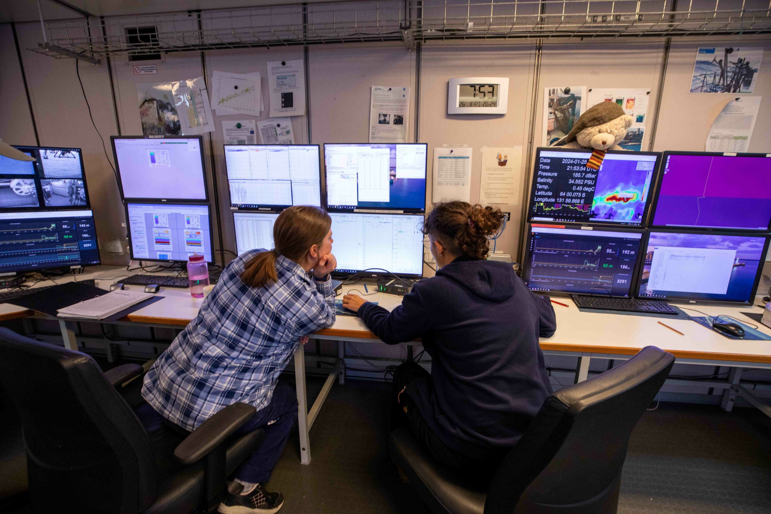
Operations room receiving data from the CTD (photo: Chris Traill) 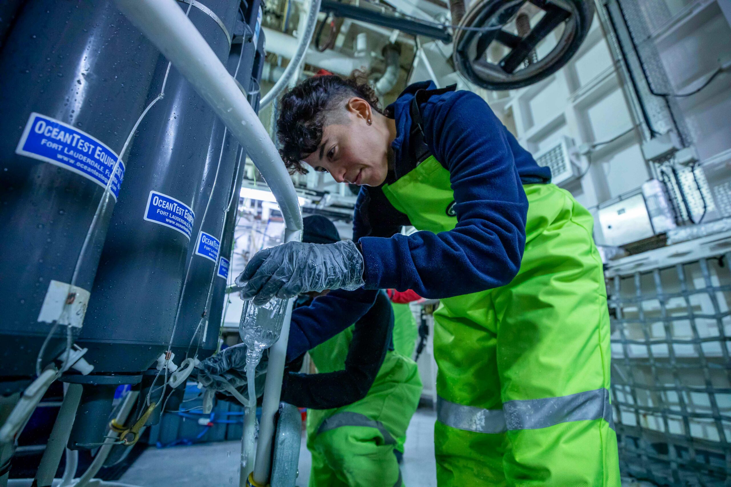
Sampling water from a niskin bottle on the CTD rosette (photo: Chris Traill) 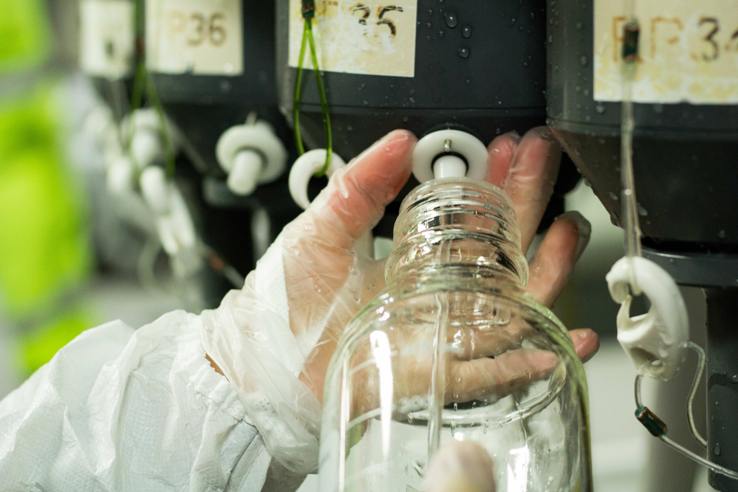
Sampling the CTD rosette (photo: Chris Traill) 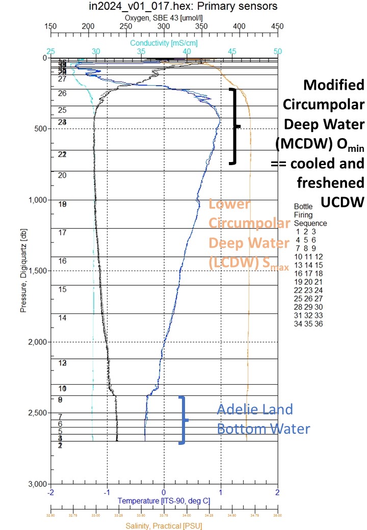
Readout from the sensors on a CTD ‘dip’ 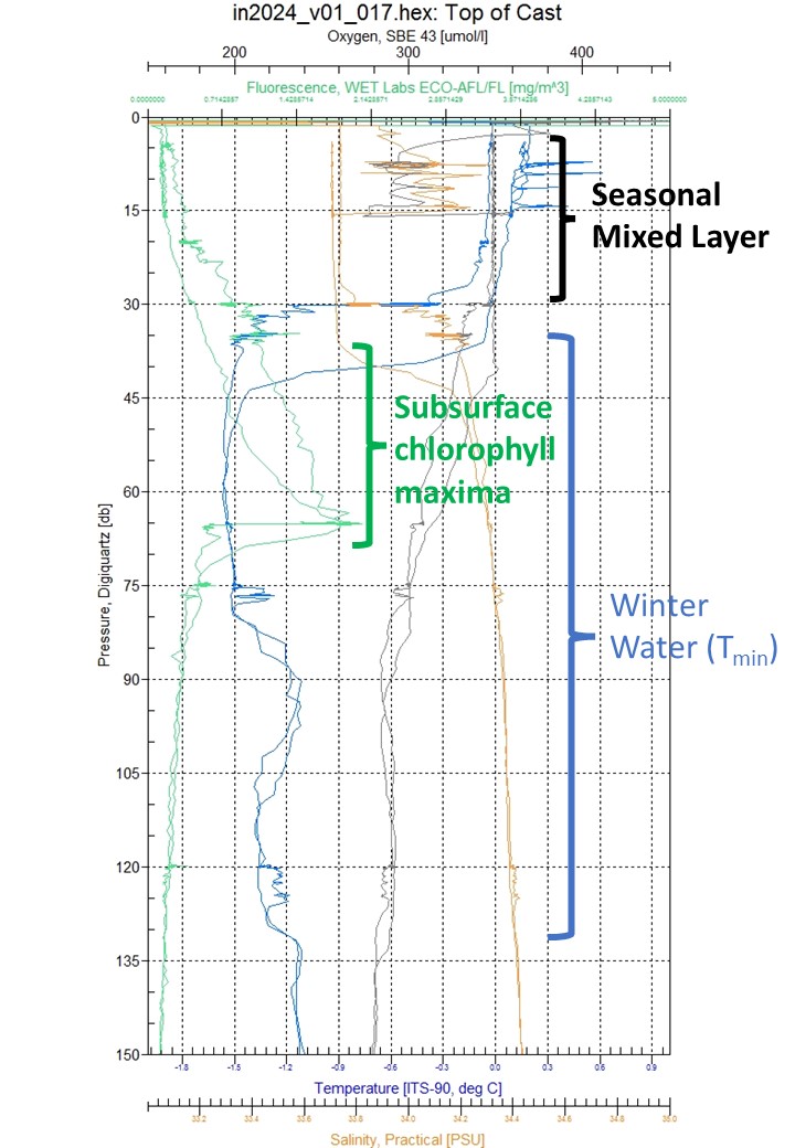
Readout from the sensors on a CTD ‘dip’
This research is supported by a grant of sea time on RV Investigator from the CSIRO Marine National Facility which is supported by the Australian Government’s National Collaborative Research Infrastructure Strategy (NCRIS).