‘Rollercoaster’ currents in Southern Ocean mapped by satellite and robot gliders
25 June 2026
Scientists have developed a novel way to measure vertical water movements in the upper Southern Ocean, by combining satellite measurements of the sea surface with underwater surveys by robot gliders.
Australian and US oceanographers have published ‘The three-dimensional structure of fine-scale, vertical velocities in the Southern Ocean inferred from space’ in Nature journal Communications Earth & Environment.
One of the authors, Dr Yann-Treden Tranchant from the Australian Antarctic Program Partnership (AAPP) at the University of Tasmania, said vertical movements are crucial to transport heat, carbon, nutrients, and oxygen between the surface and the deep ocean.
“By connecting the atmosphere to the deep Southern Ocean, these powerful small-scale vertical currents help regulate the Earth’s climate.”
“The vertical motions are strongest around ocean fronts – zones marked by sharp changes in water temperature, density, or salinity – but are difficult to observe because they occur over small areas, vary rapidly, and are often short-lived.”
“Our study found intense vertical exchanges in the upper 1000 metres of the Southern Ocean, with vertical displacements of a few hundred metres per day, much stronger and more complex than previously thought,” Dr Tranchant said.
Focus on FOCUS
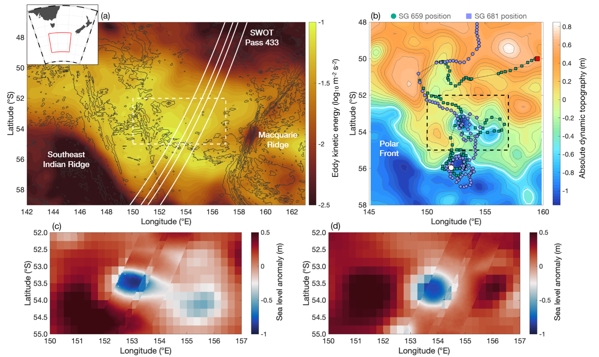
The study investigated an energetic ‘standing meander’ of the Antarctic Circumpolar Current (ACC), where the world’s strongest current bends around deep-sea mountain ranges in the Southern Ocean south of Tasmania.
Through this dynamic region runs the Polar Front, a distinct marine boundary encircling Antarctica where cold polar waters meet warmer northern waters.
In the study area was a cyclonic eddy spinning off from the Polar Front, a large strong underwater whirlpool with a difference in sea-surface height of almost a metre between the eddy core and the surrounding waters.
This ‘hotspot’ in the ACC was targeted by the FOCUS voyage on CSIRO research vessel RV Investigator in 2023. FOCUS stands for Fine-scale Observations of the (Antarctic Circumpolar) Current Under SWOT.
SWOT stands for Surface Water Ocean Topography, a satellite-borne radar altimeter able to detect slight changes of sea-surface height in high definition from orbit. 18 SWOT passes covered the FOCUS survey area in January 2024.
By that time, two autonomous ocean gliders had been deployed into the eddy and were recording the temperature, salinity and dissolved oxygen concentrations, collecting up to 3500 measurements each four-hour dive to a maximum depth of 1000 metres, across the SWOT paths as the satellite orbited overhead.
With the FOCUS voyage a highly collaborative endeavour, the ocean glider data were collected and processed by researchers at the California Institute of Technology and Australia’s national science agency CSIRO.
In addition, 15 drifters were released into the eddy to track the direction and speed of horizontal currents at the surface. Dr Tranchant and other AAPP oceanographers on the FOCUS voyage used these data in the first SWOT validation study, demonstrating the ability of the satellite to observe surface currents and fronts at very small scales.
Ocean structure in 3D
“Building on the confidence that we have in SWOT and our methods to map fine-scale surface currents, the next step was to pair this surface view from space with what’s happening in the ocean interior,” said Dr Tranchant.
“Combining the surface view from the SWOT satellite with the detailed underwater data from the gliders gave us a detailed three-dimensional picture of vertical velocities throughout the upper 1000 metres of the ocean.”
“We found vertical motions extend deep into the ocean (to at least 1000 metres), on small spatial scales (as little as ~10 kilometres across), with upward and downward velocities frequently exceeding 150 metres per day, much stronger than many large-scale ocean circulation estimates suggest.”
“Our study demonstrates that SWOT satellite observations can be used to map these previously hard-to-measure vertical motions and could eventually enable estimates of carbon, nutrients, oxygen, and heat transport across the vast Southern Ocean over time,” he said.
READ THE PAPERS:
Andrew F. Thompson, Lilian A. Dove, Yann-Treden Tranchant, Benoit Legresy, Beatriz Peña Molino, Laura Herraiz Borreguero, Zichang He & Patrice Klein (2026) The three-dimensional structure of fine-scale, vertical velocities in the Southern Ocean inferred from space. Communications Earth & Environment
(Authors’ institutions: California Institute of Technology, Brown University, Georgia Institute of Technology, Australian Antarctic Program Partnership, Institute for Marine and Antarctic Studies, University of Tasmania, CSIRO, CNRS)
First SWOT validation study: Tranchant, Y.-T., Legresy, B., Foppert, A., Pena-Molino, B., & Phillips, H. (2025). SWOT reveals fine-scale balanced motions driving near-surface currents and dispersion in the Antarctic Circumpolar Current. Earth and Space Science.
This research is supported by a grant of sea time on RV Investigator from the CSIRO Marine National Facility which is supported by the Australian Government’s National Collaborative Research Infrastructure Strategy (NCRIS).